Description
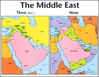
This large, classroom-size “The Middle East: Then and Now” Bible Map compares a Bible map of Israel, Egypt, Assyria and Babylonia during Old Testament times – side-by-side with a map of modern-day Middle Eastern countries – including Iran, Iraq, Egypt, Turkey, and Israel.
This clear, colorful ancient Middle East Bible map enhances Old Testament stories of Abraham, Isaac, Jacob, Noah, Moses, Daniel, Esther, and more. This Bible times wall map is perfect for Bible studies, Sunday school lessons, and homeschool Bible geography curriculum for kids.
Biblical Places Identified on the Bible Times Map:
-Bible Map of Israel, Canaan, Egypt, Cush, Sheba, Armenia
-Bible Map of the Hittites, Hurrians
-Bible Map of Nile River, Sea of Galilee, Red Sea, Jordan River
-Bible Map of Assyria, Babylonia, Sumer, Elam, Persia and Media
Modern-Day Places of Biblical Significance Identified on the Present-Day Bible Map:
-Modern map of Israel, Egypt, Lebanon, Jordan, Syria, Saudi Arabia
-Modern map of Iran, Iraq, United Arab Emirates, Yemen, Oman, Qatar, Bahrain, and Kuwait
-Modern map of Sinai Peninsula, Gaza Strip, Golan Heights, West Bank
This is a perfect VBS Bible map for kids because now they can see where Bible places are today. The print is large and the boundaries and colors make it easy to read. This biblical Middle East wall map also goes well with adult Bible studies and children’s Sunday school classes because it helps students understand the distances people traveled. It brings to life the stories of Abraham, Isaac, Jacob, Adam and Eve, Noah’s ark, the Tower of Babel, Daniel, and Esther.


Reviews
There are no reviews yet.